 www.statcan.ca/.../figures/figure3.1-en.htm
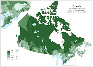
A choropleth map is a thematic map that is used to show a measurement of some sort by use of shading and/ or patterns. It provides the viewer an easy way to translate statistics to and from a map by use of the colors and patterns used. This is a choropleth map of Canada and show the percentage of population that are under age 14 in 2006. The lighter areas are for less percent and the darker areas are for higher percent.

No comments:
Post a Comment