skip to main
|
skip to sidebar
Tuesday, November 4, 2008
Lidar Map
www.csc.noaa.gov/products/
nchaz
/
htm
/intro.
htm
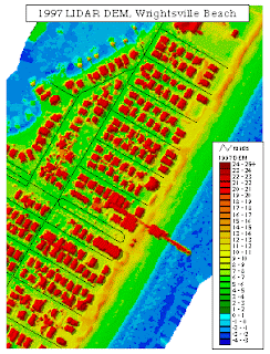
Lidar
data is remotely sensed data that is detected using
Lidar
equipment. They are usually collected with mounted laser on
aircraft's
and can document topographic change on the land and water below. This is an image over
Wrightsville
Beach in 1997.
No comments:
Post a Comment
Newer Post
Older Post
Home
Subscribe to:
Post Comments (Atom)
Map Stuff
Blog Archive
▼
2008
(50)
►
December
(12)
▼
November
(18)
Unstandardized Choropleth Map
Standardized Choropleth Map
Univariate choropleth maps
Bivariate Choropleth Map
Unclassed choropleth map
Classed choropleth maps
Range graded proportional circle map
Continuously variable proportional circle map
DOQQ
DEM MAP
DLG map
DRG
Isopleth Map
Isopach Map
Isohyet Map
Isotachs
Isobars
Lidar Map
►
October
(5)
►
September
(15)
About Me
tbaybuc
View my complete profile
No comments:
Post a Comment